
As climate change, land degradation, and human expansion continue to threaten Africa’s wildlife, technology is emerging as one of the most powerful tools in modern conservation.
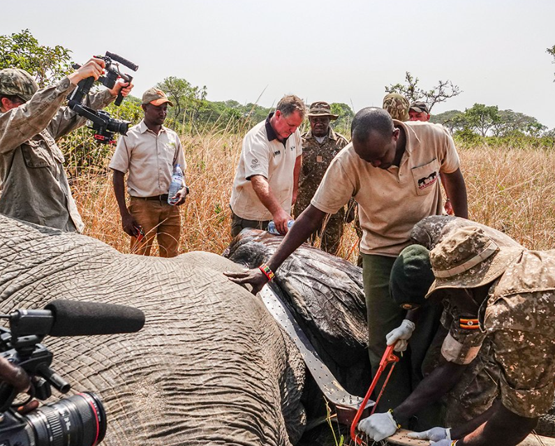
This is especially evident in the new cross-border elephant collaring initiative underway in Kidepo (Uganda), Karamoja, and Turkana (Kenya). Elephants are being fitted with GPS-enabled satellite collars to help protect their species and the communities they encounter.
Spearheaded by the Uganda Wildlife Authority, the Kenya Wildlife Service, and the Kenya Wildlife Research and Training Institute, the initiative is supported by a consortium of conservation partners. These include the Uganda Conservation Foundation (UCF), Northern Rangeland Trust, Wild Landscapes International, Save the Elephants, as well as aerial support from Tropic Air and the Mara Elephant Project.
But this effort isn’t just about tracking elephants. It’s about how data, satellites, and cross-border collaboration are reshaping the future of conservation in East Africa. Embracing this kind of innovation is no longer optional—it’s essential.
The ability to monitor elephant movements in real-time is transforming how we address human-wildlife conflict. For years, conservationists lacked the tools to predict elephant behavior, leading to reactive—and often ineffective—responses.
Now, each GPS collar sends live location data to platforms like EarthRanger. This allows rangers and researchers to monitor migration patterns, detect when elephants enter farmlands, issue early warnings to local communities, and design informed conservation and land-use policies.
In other words, technology is enabling a proactive approach. It replaces guesswork with precision—something critically needed in regions like Karamoja and Turkana, where elephants increasingly compete with people for space, water, and food.
What sets this initiative apart is its collaborative, transboundary nature. Governments, NGOs, scientists, and aviation partners are working hand-in-hand, supported by the European Union’s Nature Africa programme. It’s a rare and powerful example of regional cooperation fueled by technology and shared responsibility.
Crucially, the data collected doesn’t just stay in the cloud. Thanks to organizations like UCF, Save the Elephants, and Wild Landscapes International, the insights gathered reach the people who can act on them—wildlife rangers, policy-makers, and local leaders.
While GPS collars and satellites take center stage, the real engine behind this initiative is people: skilled veterinarians, GIS analysts, rangers, and community officers, all working in harsh and remote environments to make each collaring operation a success.
Take Dr. Singoma, a young veterinarian with over 500 animal rescues under his belt. He’s now helping lead collaring efforts in some of East Africa’s most challenging terrain.
“I’m living my dream,” he says. “Being part of this mission is a once-in-a-lifetime experience, and I’m learning every day.”
Dr. Singoma represents the new generation of African conservationists. For young professionals like him, tech-based conservation doesn’t just offer tools to protect wildlife—it offers career paths and leadership opportunities.
Ultimately, this initiative is more than a tracking exercise—it’s a model for the future of conservation: driven by real-time data, international cooperation, local expertise, and modern tools designed to protect ancient species.
If East Africa continues on this path, it won’t just save elephants—it will redefine what’s possible in wildlife conservation across the continent.
Satellites and collars may be hardware, but in the right hands, they’re instruments of hope.